 My Account
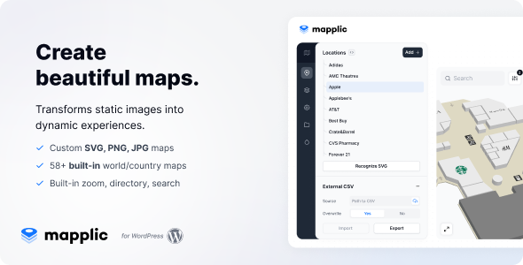
Mapplic v8.7.3 – Custom Interactive Map WordPress Plugin
Mapplic is the leading interactive map plugin for WordPress, allowing you to transform simple images or vector graphics into fully responsive and touch-friendly maps. Whether you’re creating a floor plan, an illustrated guide, or an interactive venue layout, this tool gives you the flexibility and control to bring your vision to life.
What makes it stand out
-
Add unlimited points of interest, each with its own unique icon, label, and action
-
Support for multiple levels or floors without restrictions
-
Each point on the map can have a unique URL, making direct linking possible
-
Designed to be fully responsive for smooth performance across all devices
-
Optimized for mobile and tablet users with full touch support
-
Comes with an intuitive admin panel for easy setup and customization
-
Includes a comprehensive user guide to walk you through every step
More than just a mapping tool
While services like Google Maps or OpenStreetMap are great for many uses, they don’t always offer the customization some projects require. That’s where Mapplic excels. You can upload your own visuals—whether raster images or SVG vector files—or choose from an extensive built-in collection to build interactive, clickable maps for a variety of unique applications. Here are just a few examples:
-
Floor plans for buildings like shopping centers, hospitals, airports, universities, or public institutions
-
Illustrated guides for ski resorts, theme parks, or detailed isometric designs
-
Temporary layouts for festivals, events, or seasonal sites
-
Navigational maps for moving environments like cruise ships
-
Reconstructed visuals of historic sites or ancient cities
-
Creative, fictional, or game-based maps for RPGs and other entertainment platforms
The only boundary is your own imagination—Mapplic gives you the tools to make it real.
Available beyond WordPress
Not using WordPress? No problem. Mapplic also offers a jQuery version, giving you access to the same power and flexibility for custom-built websites and other platforms.
A plugin unlike any other
What truly sets Mapplic apart is its depth and adaptability. Whether you’re building a basic store locator or a detailed multi-level navigation system, this plugin can handle it all. It lets you create interactive experiences by turning ordinary images or vector graphics into detailed maps and layouts that your users can explore.
Unlimited design freedom
With no limits on how many locations or floors you can include, you can customize each map pin with icons, tooltips, or actions that suit your purpose. Every location can be deep-linked, so users can navigate directly to a specific point. Ideal for large, complex venues such as airports, universities, or exhibition centers.
Preloaded map options
Mapplic also comes with a comprehensive set of ready-made geographic maps. You’ll find the 15 most-used maps already included—such as World, Continents, USA, Canada, Europe, Australia, UK, Germany, France, Italy, The Netherlands, Switzerland, Russia, China, and Brazil.
And it doesn’t stop there. The built-in map library continues to grow, with more free, high-quality options added regularly. These include countries like Austria, Belgium, Hungary, Japan, Mexico, Poland, Romania, South Africa, and Spain.
Optimized for smooth interaction
Every map built with Mapplic is fully responsive and crafted for seamless use on mobile devices, tablets, and even touchscreen kiosks. Features like zoom, pan, minimap, and informative tooltips ensure a polished and user-friendly experience. You can also organize locations into categories or searchable lists—perfect for helping users find a store in a mall, a department in a hospital, or a booth at a convention.


There are no reviews yet.